Hebridean Cycle Challenge and Sponsored Cycle
In Aid Of Lewis and Harris Youth Clubs Association

2011 Report Results and Photos
The Hebridean Cycle Challenge is a competitive road and mountain bike race with the option of running the off-road section instead of cycling it. The Challenge begins with a 33.6 mile road cycle from the Creed Enterprise Park outside Stornoway to Miavaig in North Harris. The race then continues with a 10.5 mile off road section through the mountains from Miavaig to Bowglas and ends with just under a mile of road running to the finish at the Scaladale Centre, Ardvourlie, North Harris. More detailed descriptions of the route and maps can be found below.
Challenge competitors can do the challenge Solo or as a Team of Two.
The Hebridean Sponsored Cycle is a non competitive event catering for casual cyclists. It begins at the Creed Business Park outside Stornoway and ends 21.3 miles later at the Scaladale Centre in Ardvourlie, North Harris.
Transportation will be provided to take bikes back to Stornoway.
Note that all entrants must be over 16 on the day of the event. Please read the Information Leaflet for further information before entering the event.
Hebridean Cycle Challenge (£30 entry fee)
Stage 1 - Creed Enterprise Park to Miavaig (33.6 miles)
Stage 2 - Mountain bike section from Miavaig to Bowglass (10.5 Miles) and on to finish at Scaladale Centre (0.85 mile)
Hebridean Duathlon Challenge (£30 entry fee)
Stage 1 - Creed Enterprise Park to Miavaig (33.6miles)
Stage 2 - Off road run from Miavaig to Bowglass (10.5 Miles) and on to finish at Scaladale Centre (0.85 mile)
Hebridean Sponsored Cycle (£10 entry fee)
Stage 1 - Creed Enterprise Park to Scaladale Centre (21.3 miles)
Road Bike Sections: Creed Park - Scaladale Centre - Miavaig
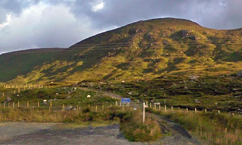
The road bike sections begin south of Stornoway at the Creed Enterprise Park. It follows the A859 south passing through Leurbost, Laxay, Balallan, Arivruaich and Bowglas before ending at the Scaladale Centre in Ardvourlie. This section is 21.3 miles and although it has no major climbs (compared to the second section!) it is constantly undulating - straight from the start!
The second 12.3 mile section introduces some serious climbing - over the pass below Clisham and again on the single track road to Miavaig.
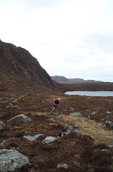
Challenge Off Road Section: Miavaig to Bowglass
Got Google Earth? Click here to open route in Google Earth or here to fly the route
Elevation Profile - Miavaig to Bowglass
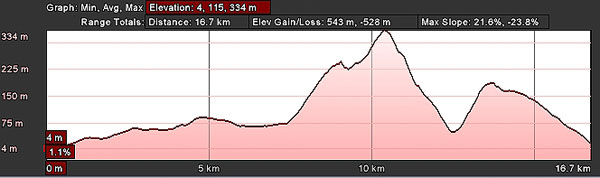
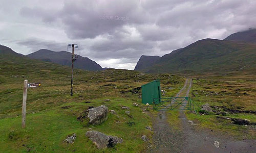
The route heads north from the green stalkers hut, following a gently rising and undulating landrover track to the Loch Voshmid fishing hut at just over 4 miles from the start. So far it is an easy ride on a good gravel surface (easy that is unless you are heading into a northerly wind!) The biggest danger here is of crashing because you are looking up at the spectacular scenery rather than watching where you are going!
At the hut, you turn right onto a narrower and more naturally surfaced trail. This has some interesting single track which flows over some hummocky glacial moraines (this whole area was covered by glaciers only 18,000 year's ago!). Care is sometimes required as you cross the river (there is no bridge so you are probably going to get your feet wet!)
This signals the start of the hard stuff - around 300m of climbing! In good conditions it is possible to clean this section but usually the surface is slippy and it is very difficult to retain traction on the steeper sections - so some shoving will probably be required. As you head to the 6 mile marker there is a short descent into a spectacular corrie below Creag Chleistir (look out for deer and eagles on the surrounding hills). Not too much respite here though as the route climbs once more up to the high point of the route at around 330m.
The descent down to the river is quite technical because of erosion to the trail. There are soft sections ready to stop you in your tracks and steep twisting turns - take care!. The descent finishes at the river which is usually easy to ford (the original bridge is washed away). If the river is too high, head about 200m upstream where a new bridge has been built but to which there is no obvious trail!
Another steep 140m climb follows which is almost certainly going to require a bit of hike a bike! Although the new improved surface makes it a lot easier than it used to be!
From the bealach it is straight forward downhill blast down to the main road - the only hazard being a quick splash through a small stream which should cause no problems. This is followed by 0.85 of a mile of gently rising new road to the finish at the Scaladale Centre.
Enjoy!